Maps
Map on-line
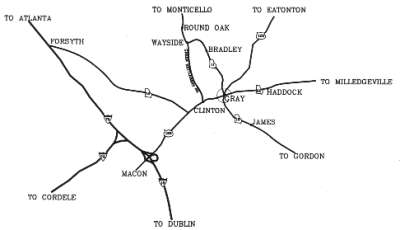
Jump to the Jones County map image below
Shows communities in Jones County and surrounding counties.
District Plats of Survey
District Plats of Survey, Baldwin County / Jones County.
Land Districts 6, 7, 8, 9, 10, 11, 12, 13.
Georgia's Virtual Vault - see Baldwin County.
Historical Maps of Georgia
Historical Maps of Georgia
Animated by Southeastern Genealogy Online (1758-1932)
Hargrett Library Historical Maps.
Map of Jones County
A map of Gray (community) and Jones County is available upon request. Send e-mail to: jcgchcom@mylink.net (Sandra McKinney, Chamber of Commerce). Remember to tell them you learned about them on the Jones County GAGenWeb site.
Land District Maps
You may purchase a land lot map from the Jones County Tax Office at:
P. O. Box 1359, Gray, GA 31032
$4.00 plus $2.00 for mailing.
Map of Jones County
Historic Maps for Jones County
We are so grateful for the Carl Vinson Institute of Government, The University of Georgia, and the marvelous maps that they have online.
1822 map - Remember Jones County was laid out in 1807.
1823 map - Changes as Bibb County was created in 1822.
1830 map - Shows Clinton and Cedar Creek, Walnut Creek and Ocmulgee River.
Towns: Midway, Blountsville, Fortville, Lannington
Waterways: Ragurs Creek, Allison Creek
1839 map
1863 map - Towns: Blountsville, Etheridge, Grab, Tranquilla, Wallace, Poverty Hill. On R.R. line: Whitaker, Griswoldville
1874 map - Towns: Blountsville, Clinton
1883 map - Towns: Round Oak, Long Shoals, Cardville
1885 map
1895 map
1904 map
1910 map
1915 map
1952 map
1970 map
1970 additional map
| Back to the top | Jones Co Page | GAGenWeb State Page | USGenWeb Page |